Evening view from my Bed(side window)....I don't think it can get any better than this....
 |
| (c)2015Horst Kelly Photographer |
As much as I wanted to...oh, stay....just one more day, I knew it was time to move on. ... my destination was in the Tombstone/Bisbee area....I was looking for a Boondocking spot, but they appeared to be South right by Douglas...I had wanted to land at Rustler Pk...which is run by the Forest Service...Its South of Wilcox, NM in the Chiricahua National Monument Area..when I called to get some directions they said it was closed for maintenance until the 12th....gave me some other places...mostly for tents and also said some of the roads where suspect at this time...I went to "Plan Z" and ended up at Tombstone Territorial Rv Park off of AZ 82.....a park geared to Canadian Snow Birds...A nice enough park with more amenities then you could ever want...and with Passport America its 16 dollars .....I decide to stay until the 10th...so Tomorrow I roll East and plan on landing at City of the Rocks CG north of Deming...will end up with a Boondocking site...the weather is suppose to be OK for solar....
 |
| Church with Supersitions...(c)2015Horst Kelly Photographer |
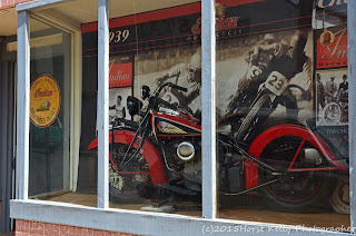
Since I was last here in 2011....I decided to do some exploring....and I found two places I had not seen previously...the first was Lowell, right at the edge of Bisbee....It was only a couple of streets and devoted to Indian Motorcycles, vintage Cars and Vintage Gas stations, etc...I spent about 45 minutes walking around...it did bring back the mid to late '50's....Terrific stuff...
 |
| Lowell...(c)2015Horst Kelly Photographer |
As I was making my way up to Bisbee, it started to turn somewhat ugly as well as when I drove into Tombstone...since I have been to both places it was no great disappointment...Tombstone is a little to commercialized for me...It's more like a "Universal Movie Set" from L.A. rather than the Historical site its Billed at...Don't think that back in the day they had too many Ranch Hands or prospectors walking around main street with a parrot on their shoulder...at least not for long...oh well...
 |
| Lowell...(c)2015Horst Kelly Photographer |
 |
| Lowell(c)2015Horst Kelly Photographer |
That reminds me...on my way down here as I was traveling on Highway 79 from Apache Junction, I came upon a Monument...It was for Tom Mix...the most famous Hollywood Cowboy of the '20's/'30's...apparently at that spot in the road he crashed his 1930 something Cord automobile and was killed...see photo below...Yes I had to stop and take some pics and read the history of the event..... he was 60 when he died....was quite the Ladies Man..married 5 times...etc....
 |
| Tom Mix write-up |
 |
| Tom Mix Road Maker |
 |
| Tom Mix Road Side Monument |
Ok, back to my stay here...The other "Find" while here was Fairbank Historic Townsite...I was about 1/4 mile from my CG when I said a sign ...turn here..I did and a couple 100 yards in was this ghost town...only a couple Building that the BLM had restored....including a Museum in the old 2 room school house...with a volunteer that works there Friday through Sunday....
 |
| Teachers House |
 |
| School House |
Here is a little History on it from a BLM website...
"Fairbank is a "ghost town" located within the San Pedro Riparian National Conservation Area (NCA), along the San Pedro River. Its life as a town began with the construction of a railroad in 1881, and it soon became an important depot as well as the closest railroad stop to Tombstone, then one of the largest western cities (15,000 in 1882).
Originally called Junction City, Kendall, then Fairbanks, it was officially named Fairbank on May 16, 1883. The name refers to N.K. Fairbank of Chicago, who helped finance the railroad.
The town, was built on an old Mexican land grant, the San Juan de las Boquillas y Nogales, which was bought by the Boquillas Land and Cattle Company in 1901. The company evicted all potential land owners, but continued to lease the mercantile building and a few residences well into the 1970's.
The Bureau of Land Management acquired the land that was once the Mexican Land Grant in 1986 as part of the San Pedro Riparian NCA."
If you enjoy Old Towns and are into History...its worth the stop and the volunteer on duty was very knowledgeable...
This evening did a little straightening and organizing of the Casita...laundry, and will grill a steak with salad and cowboy beans....I plan on pulling out of here at first light...its about 230 miles, but since its the weekend, you never know how filled up it will get....so I want to arrive as early as possible...
Until next time, Happy Trails and Thanks for taking the time to stop by!....Horst sends
 |
| Another Arizona sunset...(c)2015 Horst Kelly Photographer |


It's always nice to have a plan B,C, or Z. Would liked to have seen your report on the Chiricahua National Monument. Hear it's an unusual place with some nice rock formations. It's on my list as a stop next time we're in the area. Safe travels, my friend.
ReplyDeleteI wish I could have stayed at Chiricahua...but I guess it gives me a place to venture to next time out...One person described it as Bryce, except small hoodoo's and not he same consistently....whatever that means..:) Take care my Friend..Horst sends
DeleteSome very good camera work happening. It will be interesting when you get all the rest of the pics ready for viewing.
ReplyDeleteYour too kinds with your comments about the photography...but I'll take them.. :).....it has been a magnificent trip for me...thanks for stopping by...while you are sunning on the Gulf..Horst sends
ReplyDelete